
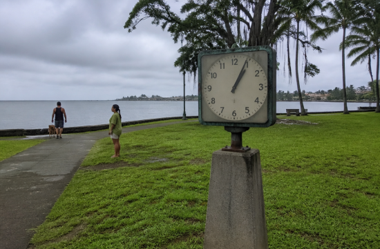
There is a strange clock standing in a park near downtown Hilo. The hands have been stuck at 1:04 for over 60 years. Until you read the monument next to it, it's easy to just walk by without a second thought.
When I first saw it, I thought it was just broken. But once I learned why the clock stopped, I found myself unable to walk away for a while.
It all started on May 22, 1960, not in Hawaii, but in South America, Chile. A magnitude 9.5 earthquake struck off the coast of Valdivia, which is still the largest recorded earthquake to date.
The distance from Chile to Hilo is over 10,000 km. A tsunami crossed that entire ocean, while the people of Hawaii were likely having dinner and preparing for bed as usual.
The waves reached Hilo 15 hours after the earthquake, in the early morning of May 23. The energy traveled across the Pacific at 400 miles per hour, and honestly, just seeing that number gives me chills.
Here comes the most heartbreaking part. The warning system worked properly.
The Pacific Tsunami Warning System, established after the 1946 Aleutian tsunami, functioned normally at this time. The alert was issued six hours before the expected arrival time, and sirens sounded. The system did its job.
Yet, 61 lives were lost in Hilo. Records show that many of the victims did not evacuate even after hearing the warning.
Why didn't they move? Looking for answers, I found that this was not just someone else's story.
Many people thought the warning was a false alarm. Some misunderstood the meaning of the sirens, and there were even those who went to the shore to watch the waves. It was a time before everyone had smartphones to see real-time updates, which likely contributed to the confusion.
Another factor was past experience. Many residents believed that since the area around Waiakea had little damage during the 1946 tsunami, they would be fine this time as well.
This part hit home for me. We often think, "It was fine last time, so it will be fine this time," whenever a hurricane warning is issued.
That day, the waves did not come just once. They came in multiple surges, with the third wave being the largest.
The third wave surged into Hilo Bay, reaching a height of 35 feet above sea level. There are records of parking meters being bent over and a 20-ton boulder being pushed back 500 feet.
That wave swept away the clock in Waiakea. The clock's hands were found in the debris, still showing 1:04, and they intentionally left that time unchanged during restoration.
Waiakea was a community with shops, schools, restaurants, and even a movie theater. Many residents were of Japanese descent. Knowing that this was a neighborhood built by immigrants working hard made me feel a deep sense of loss.
However, that town was never rebuilt. Housing reconstruction was prohibited in the low-lying coastal area that had been hit twice.
Instead, Hilo pushed forward with a project called the Kaikoʻo Project. Parks, lagoons, and green spaces were created along the coast, while residential areas were moved further inland.
The result was the Wailoa River State Recreation Area. Completed in 1965, the expansive green space where people now walk and fish is actually a buffer zone. To the untrained eye, it looks like just a beautiful park, but in reality, it's a sign that the entire city has taken a step back.
There are differing views on this decision. For residents who lost their homes, it meant a neighborhood was erased from the map.
On the other hand, from a safety perspective, there are few measures as effective as this. If the waves come again, the park will take the hit instead of the people.
I enjoy looking at data, but this situation feels different. Behind the number 61 are the individual decisions of each person.
Technology did its part back then. What was lacking was the habit of believing the warnings and taking action.
So nowadays, when I hear the siren test each month, I try not to ignore it. I think about where I would go if it were a real alert. I also check to make sure I have water and a flashlight in the car.
Many people don't even know where the tsunami evacuation zones are. There's a map available on the county emergency management site, so please check it out at least once.
And don't return immediately just because the first wave is weak. The most dangerous waves are often the ones that come later, as seen in 1960.
This year, there have been discussions about relocating this clock monument. Even if its location changes, I hope the message of 1:04 remains the same.
It's the moment of complacency, thinking it's 10,000 km away or that it was fine last time, that is the most dangerous. Hilo has been teaching us this lesson for over 60 years with that stopped clock.
If you ever find yourself in Hilo, be sure to stand in front of the Pacific Tsunami Museum and that clock. When I go next time, I plan to hold the hands of those around me and share the story of that day. I believe it will stay with them far longer than any line in a guidebook.
 VigilanteInc



 Anova US Beauty Information |
 anchor |
 Korea Tiger News |
 Alpha and Omega World |
 Florida King |
 Hilo Cat |


 American Food Information & Calories |
  Hawaii Maui Kahului |
  calvorn |
  fernando park |
  newyorker 101 |
  coffeee |
  |
|  Christopher |
  sylven |
  Sammy Beach |
  Bliss O |
  blue ocean |
  greenlight |
  Watanaka Karametibaksa |
  castle |
  xelton52 |
  carefree |
  vrixen73 |
  AZ Road Master |
  Victory 1988 |