
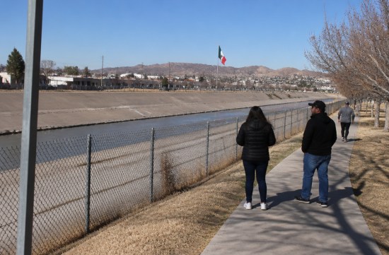
When we think of borders, we usually picture a solid line drawn on a map. However, if that line is drawn over a river, the situation changes. Rivers do not stay still.
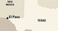
Walking through the Chamizal National Memorial south of El Paso, this simple fact weighs heavily. This land holds a dispute that the United States and Mexico have grappled with for nearly a century.
The starting point was the Treaty of Guadalupe Hidalgo in 1848. This treaty established the Rio Grande as the boundary between the two countries.
The boundary shifted in 1864. A major flood caused the Rio Grande's course to move significantly southward. Land that was originally on the Mexican side suddenly ended up on the north side of the river, meaning it was now in the United States.
The two countries established their own criteria through an agreement in 1884. In cases of gradual changes like erosion and sedimentation, the border would move along with the river. Conversely, if the river abandoned its old course and suddenly created a new one, the border would remain in its original position.
The issue was whether the 1864 flood fell into one category or the other. The United States viewed it as a gradual change, while Mexico argued it was a sudden change.
According to the National Park Service, the dispute officially began in 1895 when a landowner named Garcia informed the Mexican government that his land had crossed over to the other side of the border due to the flood.
In 1910, a three-member arbitration panel was formed under the Border Commission. It included a Mexican commissioner, a U.S. commissioner, and Canadian lawyer Eugene Lafleur as the chair. The hearings began on May 15, 1911, in El Paso and concluded on June 15.
The conclusion was to divide the land. The changes prior to the 1864 flood were deemed gradual, so that portion was considered U.S. land, while the changes caused by the flood were not gradual, thus deemed Mexican land. The U.S. commissioner disagreed with this decision.
And the United States did not accept this ruling. By rejecting the outcome after submitting to arbitration, it likely left a lasting grievance for Mexico.
For over half a century, this land remained in a state of limbo. Various U.S. presidents sought solutions, and proposals such as debt forgiveness, land exchanges, and direct purchases were discussed, but no conclusion was reached.
In the meantime, people built homes and lived on that land. Neighborhoods like Rio Linda and Cordova Gardens emerged, children attended schools, and businesses opened.
The breakthrough came from President Kennedy. On July 18, 1963, he announced that he would resolve the issue based on the 1911 arbitration ruling.
The Chamizal Agreement was signed on August 29, 1963, in Mexico City. The signatories were not the presidents but Thomas Mann, the U.S. Ambassador to Mexico, and Manuel Tello, the Mexican Foreign Minister. Kennedy passed away that November, and ratification was completed under President Johnson.
The solution was surprisingly engineering-focused. A new channel was created, lined with concrete on the bottom and walls, to prevent the river from moving unpredictably again. This channel runs through the Chamizal area and Cordova Island.
The southern side of the channel was designated for Mexico, while the northern side was for the United States. According to National Park Service data, 630 acres were transferred to Mexico, and 193 acres to the United States. This means Mexico gained an additional 437 acres.
On September 25, 1964, President Johnson and Mexican President Lopez Mateos held a ceremony at the site of the old El Paso High School.
The official transfer of land occurred on October 28, 1967. It took just over 56 years since the arbitration ruling and a little over 100 years since the flood.
At this point, I always think of people before numbers. The National Park Service notes that nearly 5,600 residents of El Paso had to relocate.
Homeowners received compensation at least at fair market value, and moving costs and some additional expenses were covered. From a real estate perspective, this seems like a well-structured compensation.
However, there are things that cannot be calculated in market terms. Neighbors, favorite stores, and schools that children attended are among them. While the land value recorded in the registry can be compensated, the time spent in the neighborhood cannot be returned.
The 193 acres received by the United States were used for the Bridge of the Americas, the Chamizal Memorial, and the site of the newly built El Paso High School. The memorial received congressional approval in June 1966 and officially opened in February 1974.
Today, if you visit the area, you will see a large red X sculpture, La Equis, and a giant Mexican flag, the Mega Bandera. According to the National Park Service, these two points mark the ends of the old Cordova Gardens.
I believe there is no need to read this story politically from one side or the other. The United States held out for a long time, and Mexico waited patiently. Ultimately, both countries stepped back a bit to find a realistic answer in the form of a concrete channel.
What I learn from this dispute is the power of perseverance. After the ruling was made, rejected, and decades of proposals and rejections, a conclusion was finally reached.
It is similar in everyday life. Whether it's a property line or a misunderstanding with a neighbor, if you rush to win, things can get tangled for a long time, but if you calmly align your standards, it will eventually resolve. In daily disputes, it probably won't take 100 years.
If you have the chance to visit El Paso, I recommend taking a walk through the Chamizal Memorial. Looking across the concrete channel at Juarez, you will quietly realize how many lives are drawn along the lines on the map.
 RubyWalker




 Art patch |

 Rice Shop Uncle BLOG |
 Noodle Noodle |

 Chino Min |

 Glow Yo |
 Tomex Train Uncle |
 Que Buena |
 hexon |


 clarion |
 Curry Dragon |
 secure |
 tredon |
 Eldorado 88 |
 donggul donggul |
 korvix |
 Noodle Zin |
 Forever Tiger Teacher |
 strongman |
 U.S. Military Recruitment Information |
 |
 cherry cherry |
 Star Way |
 Pleasant K |
 Spaghetti Flying Religion |
 Texas Migration Story |
 Forever Coco is Bangga |
 nougat |
 coloradoman |
 Village Man |