

I always tell those considering a move to Federal Way the same thing.
When living in Washington, it's important to objectively assess the risks in the area. I believe the principle that prepared individuals suffer less loss applies equally to disaster preparedness.
The western Washington region of Puget Sound is known for its beautiful natural environment of mountains and sea, but it also has various disaster risk factors due to its geography.
This means it's not just about judging based on the visible scenery.
The first thing to address is earthquakes. In the Federal Way area, there have been 35 recorded earthquakes of magnitude 3.5 or greater, and it's particularly important to note that the Tacoma Fault Line ends right in this area. The risk is fundamentally different between areas that are on the fault line and those that are not.
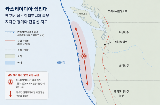
This fault is part of the Cascadia Subduction Zone, which stretches from Vancouver Island to Northern California.
Geologists consistently analyze that if a massive earthquake, known as the Big One, occurs here, it could reach a magnitude of 9.0.
The last major earthquake in Cascadia occurred about 1,100 years ago, and the most recent significant earthquake was the 2001 Nisqually earthquake, which had a magnitude of 6.8.
Just as California has discussions about the Big One, the earthquake risk here should not be taken lightly.
Therefore, I see earthquake preparedness as a necessity, not an option.
If you are considering an older wooden house, check its seismic performance, and be sure to refer to the earthquake preparedness checklist provided by King County.
Conducting a family evacuation simulation in advance can make a significant difference in an actual situation.
Landslides are also a realistic risk. Due to the mountainous terrain, hundreds to thousands of landslides occur each year, with the risk particularly increasing in winter and spring.
While Federal Way itself is relatively flat, the surrounding hilly areas tell a different story. I believe it's a reasonable approach to check the geological risk map from Washington DNR for the area before moving.
Flood risk cannot be ignored either.
The worst floods in Washington's history occurred in 2006, 2007, and 2009, with one area recording 38 inches of rainfall in just one week in November 2006.
If you are in low-lying areas or near waterways, be sure to include checking FEMA flood map ratings and flood insurance in your checklist. I've seen many cases where people overlooked this and faced difficulties later.
While hurricanes do not directly hit this area, powerful Pacific storms in winter can certainly bring strong winds and heavy rain.
To conclude, if you plan to settle in Federal Way, earthquake preparedness should be your top priority.
While the timing of a major earthquake in Cascadia cannot be specified, it is a geological fact that it will happen someday.
Having an emergency kit, a family evacuation plan, reviewing flood insurance, and understanding the geological risks of your residence. If you prepare these four things in advance, I am confident that your ability to respond to any natural disaster will be significantly improved.
The Washington State Emergency Management Division website has well-organized information on regional risks and preparedness guides.
Although the materials are in English, the content itself is not difficult, so I recommend checking it out before making your final decision on where to live.
 SausageJump




 fantastic |

 velion |

 Yo Lock Me Up |

 Rice Shop Uncle BLOG |

 My Town My Way Blog |
 Seattle - Emerald City |

 rapidfire |

 bluebird |

 corner kick |

 ssome |
 skykong |
 Shining Our Own World |
 gardener 007 |
 golfmaster |
 Nanana Nanana Nanana |
 Who's watching? |
 endone |
 RockStar |
 Casa Mia |
 You Only Live Once |
 Hardworking CPA |
 Joyce 77 |
 Runner Kim |
 My Miami Stories |
 Entip |
 Tony Park |
 Jean Claude Bundang Blog |
 DJ DC BLOG |