
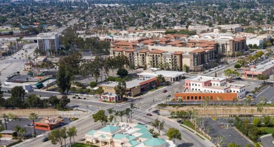
West Covina is an incorporated city in LA County, which may seem simple at first glance, but has quite interesting patterns when you look deeper into its structure.
First, the total area of West Covina is about 41 square kilometers (16 square miles). It is primarily composed of residential and commercial areas, with very little water surface area. The population density is around 6,600 people per square mile, making it closer to a naturally developed city rather than a planned city like Torrance or Irvine.
In terms of administrative divisions, West Covina operates as a single city system without separate official districts.
However, the character of the areas is distinctly divided by ZIP codes. 91790 is the western central area where the city hall is located, mixing commercial facilities and residences. 91791 is the residential area in the city center, while 91792 forms a relatively quiet residential neighborhood in the southeastern region. 91793 corresponds to a few special zones.
The City Council consists of 1 Mayor and 4 Councilmembers, totaling 5 members. The Mayor is elected from within the council and serves more as a symbolic leader rather than holding strong powers. The actual administration is handled by the City Manager. Regular City Council meetings are held every other Tuesday evening, and any resident can participate publicly.
Educational administrative districts are also operated separately. Most schools in West Covina fall under the West Covina Unified School District (WCUSD). Some boundary areas are served by the Covina-Valley Unified School District (Covina-Valley USD). Since school district boundaries vary based on home addresses, it is advisable to check the district's website for address verification before moving.
Fire and police services are also operated independently. The West Covina Police Department is a city police organization, with its own independent police system rather than being under the LA County Sheriff. The fire department is also independently operated, with several fire stations covering the entire city. This distinguishes it from unincorporated areas served by the county sheriff or county fire department.
In terms of council districts, West Covina is divided into 5 electoral districts, where residents of each district elect their respective councilmember. The boundaries of these districts are adjusted every ten years based on census results to maintain population balance. The last adjustment was made based on the 2020 census results. To check which electoral district your residence belongs to, you can refer to the district map on the city hall website (westcovina.gov).
In summary, West Covina operates as a single city system, but the ZIP codes, school districts, and electoral districts function independently. This means that when looking for a home, you need to check all three based on the address. A data-driven approach can provide much clearer insights.
 CookieSurvive
 RajoHarvest






 Arizona AZ Cowboy |
 Valley Hong |
 Mr Oh |
 ollege Mom |
 Helpful Life Stories |
 Nanana Nanana Nanana |
 United States National Administrative Organization Stories |
  cathywhite |
 Forever Tiger Teacher |
 U.S. Weather Bureau News |
  springw |
  Woooooah |
  frostpup |
  chocopup |
  Angeles Choi |
  My Heart Popper |
  comova |
  vintago |
  Sky Way |
  Top Beaches |
  folyfoly |
  ground |
  averagestudent |
  hot chocolate |
  SODA MAKER |
  james kim |
  All About Cars |
  lomira98 |
  calmbridge |