

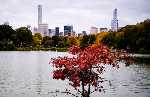
In New York, by the end of August, it can be over 90 degrees with high humidity, and just a 10-minute walk can leave you drenched in sweat. But the next morning, stepping outside, the air can feel surprisingly cool.
There are times when you might think, "Wait, is summer over?"
The biggest reason for this dramatic fluctuation in New York's summer weather is its geographical location.
New York is situated where hot, humid air from the south meets cold, dry air coming down from Canada.
When the Bermuda high pressure system strongly influences the summer, warm, humid air rises all the way to New York.
This is when we experience the typical New York heat wave. During the day, temperatures can exceed 90 degrees, and at night it remains muggy enough that it's hard to sleep without air conditioning.
In fact, the Bermuda high pressure system is commonly associated with New York's heat waves. However, this hot air does not stay in New York forever.
When cold air from Canada and the northeastern United States moves in, a cold front passes through, and the situation can change in an instant.
On such days, the sky usually becomes overcast, the wind picks up, and then a shower or thunderstorm passes through.
And the next morning, it's astonishing.
Yesterday it was 92 degrees, but today it's 78 degrees. Just like that. The more important factor is humidity.
The heat that people feel is not determined solely by temperature. When relatively dry air comes in behind a cold front, even at the same 80 degrees, the sensation can be completely different.
This is why New Yorkers suddenly have days when they think, "I guess I don't need to turn on the air conditioning today." There's also another interesting phenomenon in New York: the 'Backdoor cold front.'
Typically, we think of weather moving from west to east in the U.S., but sometimes cold air from New England and the Atlantic pushes in from the east or northeast toward New York.
That's why it's called a Backdoor cold front, as it comes in through the back door rather than the front.
When this happens, temperatures drop starting from eastern New York and Long Island, and sea breezes begin to flow in. The National Weather Service's New York office explains that this front and onshore flow significantly limit the maximum daytime temperatures in Long Island and the eastern regions.
Additionally, the Atlantic also plays a role in cooling.
In summer, land heats up much faster than the sea. As the hot air over land rises, relatively cooler air from over the sea moves in, creating a sea breeze.
According to the National Weather Service, when a sea breeze front passes, there can be sudden drops in temperature as the wind direction changes.
So even within the New York area, temperatures can vary between Manhattan, Queens, Brooklyn, and Long Island.
Especially along the southern coast of Long Island, which is directly affected by the sea, it can be significantly cooler than inland. In fact, in May 2026, the National Weather Service forecast showed that while inland temperatures rose to the upper 80s and near 90 degrees, the southern beaches of Long Island, influenced by the cold sea water, remained around 70 degrees.
Ultimately, New York summers are a bit different from the heat in Texas or Arizona.
It's not continuously hot; rather, hot and humid air can persist for a few days, and then a cold front sweeps through, suddenly providing relief.
So even in July or August, there are mornings when you open the window and find the air cool and the humidity low, which feels really nice.
Even though New York summers can be brutally hot, there are days when you get free air conditioning for a few days like this.
 AvanteN
 mooncloudtraveler2015






 Texas Migration Story |
 Peter Pan Pet |
 timemachine |
 Fortress K |
 RV Samuel's Dad |
 Beauty, Health, Lifestyle Blog |
 newyorker 101 |
 Things to Do to Buy a House |
 International Court |
 California Dreamer |
  Bearded Strawberry Smoothie |
  Heart Ticker |
  Jellia Angel |
  Moo Tang Clan |
  Khan Film Blog Production |
  Unknown Dog Walk blog |
  yenne |
  Investment Campus Home Ownership |
  virex |
  Yoyma |
  Taco Seattle |
  zenvior |
  breaddough |
  arion9 |