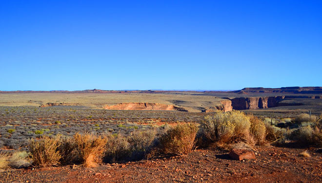
Traveling through the Arizona desert, you can feel that the atmosphere is different from other deserts.
It's not just a landscape of sand and cacti; cliffs with cracked rocks and exposed layers can be seen everywhere. It feels as if the Earth's innards are laid bare. This place could literally be called a 'geological information disclosure zone.'
By closely examining areas where fault structures are exposed, you can read how the land has moved, what earthquakes and deformations occurred in the past, and even when the area was formed.
Arizona's geological zone is a unique place where three regions meet: the Colorado Plateau, the Basin and Range (a band of desert terrain that stretches on), and the intervening transition zone. If that sounds complicated, think of it this way.
Three different land masses are pushing and pulling against each other, creating cracks. Thanks to this geographical meeting, Arizona reveals various faults, cliffs, folding structures, and twisting of rock layers. With few plants and dryness preventing soil or vegetation from covering it, the Earth's past is visible.
When you look at exposed faults, you can gather various pieces of information.
First, you can tell which direction the crust has moved. If the layers of rock are misaligned or show signs of vertical uplift, it indicates that the ground split in the past, causing one side to rise.
Second, based on the faults, you can determine where rocks from different eras are located. If older rocks are sitting on top of younger layers or if the strata are bent, it's evidence that significant forces acted in that area.
Third, erosion tends to occur more rapidly around faults, making cliffs or canyons more likely to form. Thus, many of the plateaus and cliff areas in the Arizona desert can be seen as having been created by the traces of faults.
Interestingly, faults and geological changes do not merely exist as 'museum specimens'; they also impact our lives today. For example, excessive use of groundwater in desert areas can cause the ground to sink or large cracks to form.
This phenomenon is more pronounced on existing faults or weak ground. In other words, faults are remnants of the past while simultaneously posing potential risks to us today. Human activities such as urban development, mining, and groundwater use can stimulate geological structures.
It's a misconception to think that a desert is an unchanging, tranquil landscape. Looking at the rocks and layers in Arizona reveals how much this land has moved and how it can continue to move in the future. It shows that the ground we stand on has been in constant change.
The message conveyed by the exposed fault areas of the Arizona desert seems to be that it is not just the wind and sunlight that shaped this desert, but rather the tectonic movements over millions of years that sculpted this landscape.


 Vasila's Newlywed Blog |
 Arizona AZ Cowboy |
 Who's watching? |
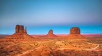
 U.S. Weather Bureau News |
 US Home Buying Information Home Insurance |
  ultron78 |
  Kitchen Ideas |
  Sandiego Auntie |
  Baguette Blog |
  Illinois alpaca |
  International Court |
  Samsung My My |
  heeve |
  Forest Gump |
  Life in the US |
  TEXAS Fishing Boat |
  silver |
  glenix39 |
  Young Kim and Cheol's Blog |
  RV Samuel's Dad |
  Seattle - Emerald City |
  AH LALA |
  Alaska Kim |
  vegas mom |