Springfield is the county seat of Greene County in Missouri, covering an area of about 82 square miles (approximately 212 square kilometers). The city is officially divided into six council election zones (Zone 1~6), with each zone electing 1 to 2 council members. In terms of everyday living areas, it can be broadly divided into Downtown, North Side, South Side, East Side, West Side, and the northwestern area near the airport.
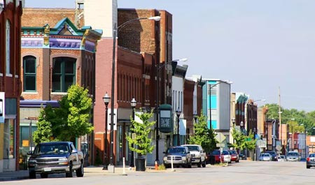
Downtown Springfield features a historic commercial district centered around Commercial Street (C-Street), Walnut Street, and Park Central Square. The Springfield Art Museum, Juanita K. Hammons Hall for the Performing Arts, and a concentration of downtown accommodations and restaurants are located here. Recently, the downtown area has seen a trend of new residential buildings and small businesses due to urban renewal projects.
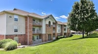
The North Springfield area is a mixed residential and commercial zone located north of Downtown, between I-44 and Kearney Street and Division Street. It has a relatively high number of older neighborhoods, with a greater proportion of low-income and immigrant communities compared to other areas. The Missouri State University campus is situated just south of downtown, but student housing is also distributed in parts north of downtown.
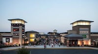
The South Springfield area, also known as the Republic Road Corridor, is home to the most active retail commercial district in Springfield, following the Republic Road and Battlefield Road corridor. Battlefield Mall, large retailers (Walmart, Target, Costco), fast-food chains, and car dealerships are concentrated here, meeting a significant portion of shopping demand. There are also plenty of restaurants and medical facilities.
The East Springfield area has developed around Glenstone Ave and National Ave, featuring a mix of middle-class residences and commercial facilities. Some Korean-related businesses in Springfield are located near this corridor. The West Springfield area, near Kansas Expressway and West Bypass (US-160), has relatively new residential developments coexisting with some industrial zones.
The remaining areas of Greene County outside Springfield are unincorporated areas, directly governed by the county. Incorporated cities within Greene County include Battlefield, Republic, Nixa, Ozark, Willard, and Strafford, each with its own city government. These satellite cities are within Springfield's commuting zone, effectively forming a metropolitan living area.
The ZIP codes for downtown Springfield range from 65801 to 65897, with the most commonly used codes being 65801, 65802, 65803, 65804, 65806, 65807, 65809, and 65810, varying by residential area. It is useful to verify the ZIP code accurately when searching for addresses, as it plays an important role in school districts, delivery areas, and insurance rate calculations.
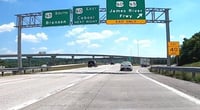
Major transportation routes include east-west I-44, Chestnut Expressway (US-66), and Battlefield Road, as well as north-south National Ave, Glenstone Ave, Kansas Expressway, and US-65. During peak commuting hours (7-9 AM, 4-6 PM), congestion can occur on these major roads, so it is advisable to use alternate routes depending on your destination. Google Maps or Waze can help in understanding local traffic conditions.
 Core81
 KoalaNapRun


 RV Samuel's Dad |
 zanero |
 Solo Yolo |
 Cali M Law Group |
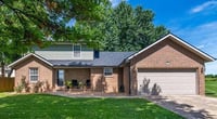
 calvor |
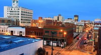
 Investment Information News Update |
 ramen |
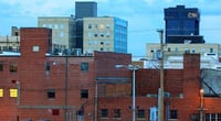
 Mina Kim |
  Leapfrog Move |
  korvix |
  Oh my Julia |
  Eagle in America for Five Years |
  average life |
  All About Real Estate Information in the USA |
  Epoca News |
  Learn English Accurately |
  Tracking 60 Minutes News |
  selviro |
  Bearded Strawberry Smoothie |
  Premium Gas Camp |
  My Life is High Breeze and Gentle Wind |
  Jean Claude Bundang Blog |
  Encyclopedia of New York and Surrounding Areas |
  American National Singing Contest |
  Diamond King |