
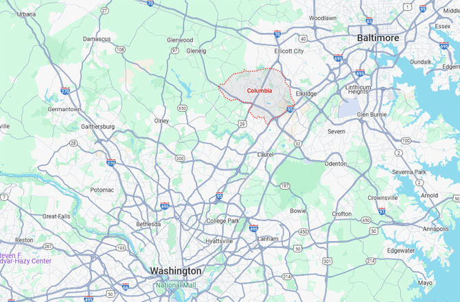
Columbia, Maryland is a transportation hub located between Washington D.C. and Baltimore.
If you unfold a map, you can see several major freeways that run through the heart of Columbia, connecting the city like blood vessels. This makes commuting, travel, and business trips convenient, and the area serves as a central axis connecting the Washington metropolitan area and the Baltimore economic zone. The most important road is Interstate 95 (I-95).
This is a representative highway that runs north and south through the eastern United States, forming a massive corridor from Miami to Maine. Columbia is roughly at the midpoint of I-95, making it about a 20-minute drive north to Baltimore and 40 minutes south to Washington D.C. This stretch is crowded with commuter traffic during weekday mornings and evenings, but the wide road and well-maintained rest areas and exits allow for relatively smooth travel. As a result, residents of Columbia can easily commute to major cities like Baltimore, Silver Spring, Rockville, and Tysons.
The second most important road is Route 29 (Columbia Pike). This road is a key thoroughfare that runs through the center of Columbia and is one of the most frequently used freeways by local residents. It connects north to Ellicott City and Catonsville, and south to Silver Spring and the outskirts of Washington D.C. While it can be somewhat congested during rush hours, there are many commercial areas and shopping malls along the route, naturally connecting the living spaces. There are also many corporate office buildings, hospitals, and IT company offices clustered around the road.
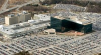
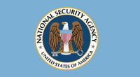
Additionally, Route 32 (Patuxent Freeway) plays a very important role in Columbia. This road stretches east-west, connecting to Laurel to the east and the NSA headquarters and Fort Meade to the west, as well as Clarksville and Glenwood. As you drive along Route 32, you often see military facility signs, with the most famous being the National Security Agency (NSA).
The NSA headquarters is located about a 15-20 minute drive from Columbia, situated within Fort George G. Meade. It is one of the largest intelligence agencies in the world, performing key missions such as electronic information collection, cybersecurity, and cryptanalysis. From the outside, it looks like an ordinary military base, but inside it is a highly secure facility filled with advanced technology and security systems.
Nearby, the U.S. Cyber Command is also located, making it effectively the center of America's digital security. For this reason, many companies related to information technology (IT), cybersecurity, and data analysis are concentrated near Columbia, and many related professionals often reside in the area. In fact, Columbia is sometimes referred to as the "tech belt of the Washington D.C. outskirts."
In addition to the NSA, several important government agencies and research facilities are clustered in the area. For example, just a short drive north on I-95 leads to the Social Security Administration headquarters near Baltimore, and nearby is the Centers for Medicare & Medicaid Services (CMS) headquarters. These two agencies are core organizations overseeing social security and healthcare administration in the U.S., so many federal employees and consultants reside or commute from the Columbia area.
Also, a little further east is the Applied Physics Laboratory (APL) located in Laurel. This is a research institution under Johns Hopkins University, conducting advanced research in various fields such as defense, space, and medicine. It also collaborates on many projects with NASA, which is one reason why scientific and technological talent is concentrated in the area.
Thus, Columbia is not just a "great place to live" but has established itself as a strategic hub for U.S. federal government and defense-related agencies. Therefore, security firms, tech startups, and government consulting companies are densely located around the city.


 creamcat |


 Progressive Invincible Blog |
  Potato House |
  ultron78 |
  Kitchen Ideas |
  Sandiego Auntie |
  Baguette Blog |
  Illinois alpaca |
  International Court |
  Samsung My My |
  heeve |
  Forest Gump |
  Life in the US |
  TEXAS Fishing Boat |
  silver |
  glenix39 |
  Young Kim and Cheol's Blog |
  RV Samuel's Dad |
  Seattle - Emerald City |
  AH LALA |
  Alaska Kim |
  vegas mom |