
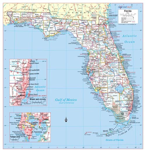
When looking at a map of the United States, the long, peninsula-shaped Florida stands out.
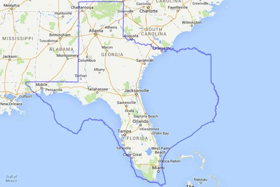
This often leads to the perception that Florida is a large state, but when placed next to a big state like Texas, the difference is quite apparent.
Texas is said to be more than four times larger than Florida. When you place Florida next to Texas, you might think, "Oh? Is it really that small?"
However, due to strong associations with summer vacation spots, Disney World, Miami, retirement cities, and Key West, the size may be exaggerated in our minds.
Of course, this doesn't mean it's a small state. In terms of area, it ranks about 22nd in the U.S., which is quite spacious. It's just that compared to the image of a 'vast southern land' we have, it feels surprisingly medium-sized.
Geographically, Florida is surprisingly low and flat. Being surrounded by water, most of the land is at a similar height to sea level, resulting in many swamps, marshes, and wetlands. Therefore, when it rains heavily or a hurricane hits, flooding is likely. On the other hand, there are almost no deep mountain ranges or high hills inland, leading to an overall flat landscape.
Still, there are some noticeable high points. The highest point in Florida is Britton Hill, located in the northwestern Panhandle, which is about 105 meters above sea level.
When compared to the highest points in the 50 states, it is the lowest peak, which can be a bit amusing. It's a gentle hill that feels almost embarrassing to call a mountain, and you can drive right up to it.
Additionally, Florida's elongated shape makes it appear longer vertically on the map, but its width is not as expansive.
Most of the population is concentrated along the coastline, so the inland areas tend to leave a lesser impression.
In the central part, there is a sandy hill area called Lake Wales Ridge, which is slightly higher than the coastline due to its geological history of water flow.
Within it is a hill called Sugarloaf Mountain, which is about 95 meters above sea level, considered relatively high in the peninsula region. From the top of the hill, the surrounding area appears almost flat, making it feel even higher.
Ultimately, only the 'bright cities where people gather' are magnified in memory, leading to the misconception of a vast region.
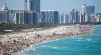
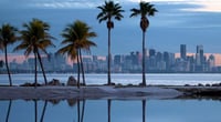
When you see photos of Miami, Tampa, and Orlando in Florida, it looks like an endless vacation paradise, and it is often referred to as a retirement haven, attracting people from the north every winter. With such stories attached, the image naturally expands.
Florida is characterized by flat plains, coastal lowlands, and wetland ecosystems rather than mountainous landscapes. The lack of elevation change means that while driving, you might suddenly encounter a lake or wetland popping up amidst the endless flatlands.
In detail, Florida is wide, but the upper Panhandle region is laid out long, making space utilization more complex than expected, and the extensive wetlands, protected areas, and lakes in the central region reduce the perceived size of habitable land.
While it may look wide on the map, the actual living space is thinly stretched along the coastline.
In the end, Florida is a state whose image is larger than its size. Warm weather, beaches, tourist attractions, and retirement culture have expanded that image.
When you compare the reality on the map with the image in your mind, you might find yourself smiling and thinking, "It's smaller than I thought?"
However, the lifestyle and energy contained within it are much larger than the area on the map.
Perhaps that's why the expression that Florida has a psychological size larger than its physical size might be fitting.


 Taco Bell Candy Note Blog |
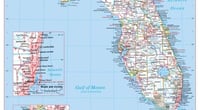
 Splendid Mission |
 American Golf Course Travelogue |
 oh my salami |
  Kitchen Ideas |
  Sandiego Auntie |
  Baguette Blog |
  Illinois alpaca |
  International Court |
  Samsung My My |
  heeve |
  Forest Gump |
  Life in the US |
  TEXAS Fishing Boat |
  silver |
  glenix39 |
  Young Kim and Cheol's Blog |
  RV Samuel's Dad |
  Seattle - Emerald City |
  AH LALA |
  Alaska Kim |
  vegas mom |
  Eating Gukbap and Working Hard Deer |