
When you unfold a map of the United States, Maryland stands out with its oddly shaped outline.
It seems to be wedged between Pennsylvania to the north, cradling the Chesapeake Bay to the south, and tapering off as you move westward.
This strangely connected shape leads people to wonder, "Why does it look like this?" The answer lies in a complex interplay of historical, political, and geographical reasons.
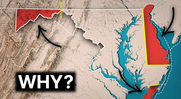
The primary reason stems from boundary disputes during the colonial era. In the 17th century, the British crown divided land in the Americas among various noble families, but the boundaries were often unclear, leading to many issues. Notably, a boundary dispute known as the 'Mason-Dixon Line' occurred between Maryland and Pennsylvania.
This line was established in the 1760s by two British surveyors, Charles Mason and Jeremiah Dixon, and it defined Maryland's northern boundary, creating the unique outline we see today. The northern boundary was drawn almost straight, while the southern boundary became curved due to the Chesapeake Bay and the border with Delaware.
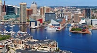
The Chesapeake Bay is also a major contributor to Maryland's distinctive map. As the largest estuary in the United States, it cuts through the middle of Maryland, resulting in a division between the eastern and western parts of the state. Thus, the eastern coastal area is commonly referred to as the 'Eastern Shore,' while the rest is called the 'Western Shore.' It's quite unique that a single bay can divide living areas within the same state.
At the western edge, there is a part where Maryland becomes unusually narrow. This section, wedged between West Virginia and Pennsylvania, is only a few miles wide, appearing almost like a thread on the map. This narrow strip resulted from the complicated land division processes involving Virginia, Pennsylvania, and Maryland during the 18th and 19th centuries. In fact, this narrow area was strategically important as a military stronghold and was often a battleground during the Civil War.
Another interesting aspect is that the boundary with Delaware is drawn in a nearly circular shape. A circle with a radius of 12 miles was drawn around the city of New Castle to define the boundary, which is a very rare case in the entire United States.
Thus, the northeastern corner of Maryland has a unique outline where straight lines and curves bizarrely connect.
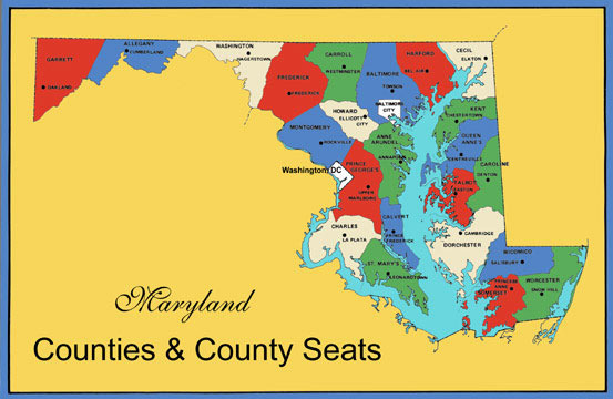
Another reason why Maryland's shape appears strange is that the overall size of the state is not very large, yet it encompasses a variety of geographical elements. To the east, there are seas and wetlands; in the center, there are the Chesapeake Bay and surrounding fishing towns; and to the west, it extends to the Appalachian Mountains. Thus, just by looking at the map, it seems as if several states have been forcibly combined into one. However, this is also part of Maryland's charm, as it can showcase diverse landscapes and cultures within a small area.
In fact, people often refer to Maryland as "America in Miniature."
With beaches, rivers, lakes, mountains, rural areas, and cities all included, one can experience various aspects of America within this small state. Viewed this way, the oddly shaped outline of Maryland on the map is not a discomfort but rather an element that gives it a special character.
What I felt while examining the map of Maryland is that each complex outline of the state is not just randomly drawn; they all carry history and stories.
The combination of political disputes from the colonial era, geographical conditions, and people's lifestyles has created the unique shape we see today. Instead of simply concluding that it is "strange," it becomes much more interesting to ponder, "What stories are hidden within it?" as you look at the map.
Ultimately, the reason Maryland appears to have the strangest shape on the U.S. map is due to the long-standing boundary disputes, natural features like the Chesapeake Bay, and unique agreements all intertwined.


 strawberry |
 maryland park |


 Illinois alpaca |
  International Court |
  Samsung My My |
  heeve |
  Forest Gump |
  Life in the US |
  TEXAS Fishing Boat |
  silver |
  glenix39 |
  Young Kim and Cheol's Blog |
  RV Samuel's Dad |
  Seattle - Emerald City |
  AH LALA |
  Alaska Kim |
  vegas mom |
  Eating Gukbap and Working Hard Deer |
  My Town My Way Blog |
  Alabama Bang |