

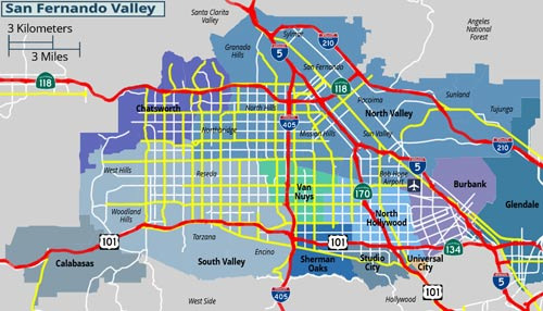
The first thing you notice when living in San Fernando is the traffic.
It looks quite good on the map, but it's a heavily congested area. With Interstate 5, California State Route 118, and California State Route 210 passing nearby, theoretically, you can access anywhere in LA quickly.
Especially with well-established routes heading north, east, and south, it wouldn't be wrong to call it a transportation hub based on its location.
The problem is that everyone who has driven here says the same thing. Once rush hour starts, the concept of distance on the map completely collapses. From 7 AM to 9 AM and 4 PM to 7 PM on weekdays, it's common for I-5, 118, and 210 to all be congested at the same time.
It's about 20 miles from San Fernando to downtown Los Angeles, and while it usually takes 25 to 30 minutes, during these times, it often takes over an hour. What matters is not the "distance" but the "choice of time." In reality, it's practical to expect travel times to be 1.5 to 2 times longer than what Google Maps shows.
Public transportation exists, but if you have high expectations, you might be disappointed. Lines like 236 and 240 of the Los Angeles Metro bus connect San Fernando with surrounding areas. Basic travel is possible, but long wait times and the need for transfers often significantly increase actual travel time. Especially during rush hours, if the buses get stuck, the feeling of fatigue increases.
A commonly discussed alternative is the Metrolink Ventura County Line. This commuter train connects Chatsworth to Union Station, and if used well, it can change the situation quite a bit. It's about a 10 to 15-minute drive from San Fernando to Chatsworth station, so access isn't difficult. Using the train allows you to escape traffic stress and utilize travel time for work or reading, which is a significant advantage. However, since the schedule isn't very frequent, it's essential to check if it fits your schedule.
Realistically speaking, trying to live in this area without a car is quite challenging. It's not a city like New York or Chicago where public transportation is the center of life. While it's possible to rely on Uber or Lyft, in the long run, the cost can be quite burdensome. Ultimately, most residents primarily use their own vehicles.
If you do drive, there's one important point to consider. Sticking only to the freeways can often be slower.
Identifying alternative routes using local roads in advance can help reduce perceived travel time. In such cases, real-time traffic apps like Waze are almost essential. They continuously adjust routes based on accidents, construction, and unexpected congestion, making them more of a survival tool than just a navigation app in LA.
Ultimately, traffic in San Fernando is a battle of "good location + bad timing." The location itself is certainly an advantage, but if you choose the wrong time, that advantage can quickly turn into a disadvantage. Those who have lived in this area for a long time all come to a similar conclusion: traffic congestion is not something to avoid but something to manage. Accepting this can significantly reduce stress in daily life.
 BootedPizza
 TomatoAtmos
 GrayPhone
 WheresMoney




 Gold Bar |
 Pirate Ship Popcorn Maker |
 Montgomery Mom |
 Anjollinya Blog |
 Taco Seattle |
 productionblog |
 All About Real Estate Information in the USA |
 fernando park |
 Valley Bang |
 U.S. Military Recruitment Information |
  Coastal city |
  meonetoo |
  Winter bear |
  Peach Jam Eating Laughter |
  Nando Raldo |
  American Man in a Mask |
  wendra |
  silver |
  bada2002 |
  horizon |
  Nanana Nanana Nanana |
  victoria jung |
  Kkikki Ppappa Shout Out Loud |
  Lululala |
  Toaster Pizza Magic Show |
  Utah, the Most Livable State |
  nortrix |
  Mau Nui |
  novapixel |
  fixed |