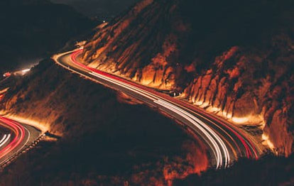
After the large-scale wildfires in Los Angeles, concerns grow over landslides and mudflows due to heavy rain.
January 16, 2025 - The recent large-scale wildfires in Los Angeles, California, have caused severe damage that could be recorded as one of the worst disasters in American history. Although the wildfires have been contained, experts warn that the risk of landslides and mudflows combined with heavy rain still remains.
Jeremy Lancaster, a geologist with the California Geological Survey, stated, "The danger does not end after the fires are extinguished," adding, "The ground becomes hardened and vegetation is lost, which significantly increases the likelihood of mudflows and landslides when it rains."
The U.S. Forest Service and California are analyzing soil damage caused by the fires and are creating risk maps by combining satellite imagery with on-site soil analysis. These maps are being developed to indicate areas at high risk of flooding and landslides.
Jason Keen from the U.S. Geological Survey warned, "Mudflows are much more dangerous than simple flooding," explaining that this phenomenon, where soil, rocks, and trees mix with water and flow rapidly, is like a 'flood on steroids.'
In the burn area near the San Gabriel Mountains in the Eaton region, artificial reservoirs have already been installed to prepare for mudflows, but approximately 2 million people across California live in areas with a high risk of mudflows, so the danger still persists.
Experts are on alert for additional heavy rain and landslide risks, emphasizing the need for thorough preparations for residents' safety.


 U.S. Weather Bureau News |

 My Town My Way Blog |
 Vivid Information US News |
 ultron78 |
  Kitchen Ideas |
  Sandiego Auntie |
  Baguette Blog |
  Illinois alpaca |
  International Court |
  Samsung My My |
  heeve |
  Forest Gump |
  Life in the US |
  TEXAS Fishing Boat |
  silver |
  glenix39 |
  Young Kim and Cheol's Blog |
  RV Samuel's Dad |
  Seattle - Emerald City |
  AH LALA |
  Alaska Kim |
  vegas mom |