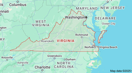
Population
- Total Population: Approximately 8,700,000 (estimated for 2025).
- Population Growth: Steadily increasing in recent years due to urbanization and migration in the Washington D.C. metropolitan area.
- Major Cities: Virginia Beach, Richmond, Norfolk, Arlington, Alexandria.
Racial Composition
Virginia is a state where diverse races coexist, with the main racial composition as follows.
- White: Approximately 62%
- African American: Approximately 19%
- Hispanic/Latino: Approximately 11%
- Asian: Approximately 7%
- Main Asian communities: Concentrated Korean, Indian, and Chinese communities, particularly prominent in Northern Virginia.
- Other Races and Mixed: Approximately 1%
Median Income
- Median Household Income: Approximately $81,000 (estimated for 2025).
- This is higher than the national average (approximately $70,000), due to proximity to Washington D.C. and the development of the IT and defense industries providing economic opportunities.
- Regional Differences:
- Northern Virginia (Arlington, Fairfax County): Relatively high income level of over $100,000.
- Southwestern and rural areas: Relatively low at about $50,000 to $60,000.
Below are the major freeways passing through Virginia.
Interstate 95 (I-95)
- Description:
A major highway running north to south along the eastern coast of the United States, one of the most important transportation axes in Virginia.- Starts from Washington D.C., passing through Richmond, Fredericksburg, Petersburg, and continues south to North Carolina.
- Main Uses:
- Essential for commercial transportation and inter-regional travel, crossing Virginia from north to south.
Interstate 81 (I-81)
- Description:
A highway running north to south along western Virginia, located along the eastern boundary of the Appalachian Mountains.- Starts in Winchester, passing through Roanoke, Harrisonburg, and Bristol.
- Main Uses:
- A central road for logistics and transportation, primarily used by commercial trucks and long-distance drivers.
Interstate 64 (I-64)
- Description:
The main east-west freeway in Virginia, starting from West Virginia and traversing east through Virginia.- Starts in Roanoke and extends to Charlottesville, Richmond, and the Hampton Roads area.
- Main Uses:
- Responsible for east-west connections, particularly important for traffic between Richmond and Virginia Beach.
Interstate 66 (I-66)
- Description:
A highway connecting Washington D.C. and Northern Virginia.- Starts in Arlington and extends to Fairfax and Front Royal, connecting with I-81.
- Main Uses:
- Heavily used by commuters traveling to and from Washington D.C., serving as a traffic hub for Northern Virginia.
Interstate 85 (I-85)
- Description:
A highway passing through Petersburg in the southwestern region, continuing south to North Carolina. - Main Uses:
- Connects to the Southeast, primarily used for commercial transportation and long-distance driving.
Interstate 495 (I-495, Capital Beltway)
- Description:
A circular road surrounding Washington D.C., passing through Northern Virginia and extending into Maryland. - Main Uses:
- Supports traffic in the Washington metropolitan area, with many government and military-related movements.
U.S. Route 29 and Route 50
- Description:
U.S. Route 29 connects Northern Virginia with Charlottesville and Lynchburg, while Route 50 passes through Washington D.C. and extends to western Virginia. - Main Uses:
- An important alternative route for local travel and medium-distance trips.


 Next Year, Let's Become Rich |
 So Good Day |
 Victormon |
 Great TOWN NEWS |
  ultron78 |
  Kitchen Ideas |
  Sandiego Auntie |
  Baguette Blog |
  Illinois alpaca |
  International Court |
  Samsung My My |
  heeve |
  Forest Gump |
  Life in the US |
  TEXAS Fishing Boat |
  silver |
  glenix39 |
  Young Kim and Cheol's Blog |
  RV Samuel's Dad |
  Seattle - Emerald City |
  AH LALA |
  Alaska Kim |
  vegas mom |