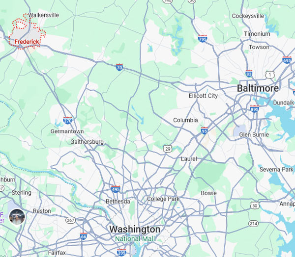
When you unfold a map and look at Frederick, Maryland, you realize it occupies an interesting location.
It is at the apex of the Washington D.C. and Baltimore triangle, yet slightly away from the noise and congestion of the two major cities. That is the charm of Frederick. Looking closely at the map, Frederick is at the center of transportation. The I-70 highway stretches east and west, while I-270 extends south, leading directly to Washington D.C., and to the north, it connects to the Pennsylvania border. It is truly a city that embodies the word 'intersection.'
Historically, this spot was an important trade route, and it feels like that tradition continues today. When viewed from above, the city is surrounded by gentle hills and wide plains, with a mountain range stretching to the west. This mountain range is part of the Appalachian Mountains, with its green ridges gently enveloping the city.
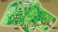
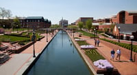
From the map, Frederick appears to be a city that lies on the 'border where mountains meet the city.' It is a structure where nature serves as the backdrop and part of daily life. In fact, if you look closely at the city center, 'Carroll Creek Park' stretches like a waterway. It appears as a thin line on the map, but in reality, it is a park designed like a small canal. Restaurants and shops line both sides, and the walking paths connect, making you feel that this city is not just a transportation hub but a 'walkable city.'
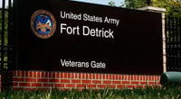
From the satellite images on Google Maps, Frederick's downtown is densely packed with brick buildings, and the surrounding area smoothly transitions into residential neighborhoods, schools, and farmland. The red roofs of the city center blend naturally with the greenery of the suburbs, making it feel like there is no separation between the city center and the outskirts. Thanks to good urban planning, the balance between the center and the outskirts looks favorable. Another notable feature is 'Fort Detrick.' On the map, there is a large green area to the north of the city, which is the U.S. Army's biomedical research institute. It is also the largest employer in Frederick. It is fascinating that public facilities are close to the city center while harmonizing with the surrounding environment. If it were a major city, such facilities would have been pushed to the outskirts, but Frederick is rather integrated with the city.
The airport is also noticeable. There is an airport named 'Frederick Municipal Airport' located to the east. It is not an international airport, but it is actively used for small planes and private aviation. The runway appears long on the map, and right next to it is the road leading into the city center. Looking at it this way, Frederick is quite well-structured for its size.
Turning your gaze outside the city, to the west lies Catoctin Mountain National Park, and to the north, you can see the road leading to rural Pennsylvania. Perhaps that is why some people refer to Frederick as 'the breathing space of the Washington metropolitan area.'
Just looking at the map makes that statement understandable. Although it is within a metropolitan area, geographically, it is a city closer to nature. The structure where the urban and rural blend naturally allows Frederick residents to enjoy hiking or fishing just a 10-minute drive away on weekends. From the map, you can feel that this city resonates well with the word 'balance.'
Not too big, not too small, not too urban, and not too rural—just right in between. And transportation, nature, history, and housing are all mixed in moderation. Looking at Frederick on a map, it feels like more than just a city; it resembles a 'living geography textbook.'


 kiwiii |
 ultron78 |
  Kitchen Ideas |
  Sandiego Auntie |
  Baguette Blog |
  Illinois alpaca |
  International Court |
  Samsung My My |
  heeve |
  Forest Gump |
  Life in the US |
  TEXAS Fishing Boat |
  silver |
  glenix39 |
  Young Kim and Cheol's Blog |
  RV Samuel's Dad |
  Seattle - Emerald City |
  AH LALA |
  Alaska Kim |
  vegas mom |